
10 Mahuika Crater
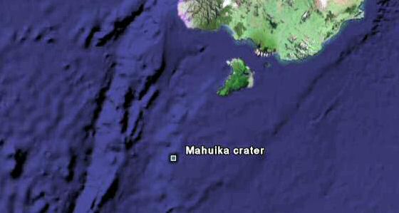
In 2003, a member of the Holocene Impact Group named Dallas Abbott and her colleagues from the Lamont-Doherty Earth Observatory of the Columbia University published a paper that identified the location of a submarine crater on the southern edge of the New Zealand continental shelf, just south of the Snares Islands, 120km southwest of Stewart Island. It was given the name Mahuika crater. The crater is 20 ± 2 kilometers wide and over 153 meters (501 feet) deep. Based on elemental anomalies, fossils, and minerals, Abbott argues that an impact event occurred around 1443 AD. (568 years ago). A later study by Edward Bryant placed the impact date on February 13, 1491.
Around the year 1400, the natives of New Zealand abandoned their southern coastal settlements and moved inland. A large number of volcanic eruptions occurred in New Zealand during the 15th century. Rangitoto Island was formed in the Hauraki Gulf near Auckland. A collection of animal species became extinct in New Zealand towards the end of the 15th century, including the moa, which were eleven species of flightless birds, the giant Haast’s Eagle, and the flightless predatory Adzebills.
Researchers were attracted to the area after it was discovered that a large collection of beach sand is present on Stewart Island 220 meters (721 feet) above sea level at Hellfire Hut and 150 meters (492 feet) above sea level at Mason Bay. In eastern Australia, there are megatsunami deposits with maximum run-ups of over 130 meters (426 feet) and a C-14 age of 1500 AD. Megatsunami deposits also occur on the eastern side of Lord Howe Island in the middle of the Tasman Sea, implying a source crater further east, which is towards the Mahuika crater.
The largest historical earthquakes on record have produced a maximum tsunami range of 40 to 60 meters (131-196 feet). Abbott et al. has suggested that a bolide impact, including the collision of a large meteorite, asteroid, comet, or other celestial object, would explain both the geological and anthropological evidence better than an earthquake. The most reliable and widespread evidence found at the site are natural glass rocks called tektites. Tektites form when a massive impact liquefies its target and sends melt into the atmosphere. The Mahuika tektite field contains glassy tektites that appear orange, light green, and clear in visible light. Tektites have been found over 220 km from the crater.
Wollongong University geographer Ted Bryant believes the tsunami may have reached the coast of New South Wales, where he has found evidence of waves up to 130m high that hit about AD 1500. Australian author Gavin Menzies has claimed that a mega-tsunami could have caused the destruction of all but one of 100 ships he says were dispatched by China to circumnavigate the globe in AD 1421. The New Zealand tsunami expert Dr James Goff disagrees with the claims and says there is no evidence that an impact event occurred so recently. The discovery of the Mahuika crater remains a controversial subject.
9
Younger Dryas Impact Hypothesis

The Younger Dryas stadial, also referred to as the Big Freeze, was a geologically period of cold climatic conditions and drought that began in 10,800 BC (12,811 years ago). The cause of the Big Freeze has been a controversial subject. Nothing of the size, extent, or rapidity of the climate change has been experienced since. The Big Freeze replaced the forest land in Scandinavia with glacial tundra. It caused the level of snow accumulation in the mountains to increase and the North American Clovis culture disappeared after the event. The climate change is correlated with the extinction of Pleistocene megafauna.
A collection of geologists have claimed the Big Freeze was caused by the collapse of the North American ice sheets, while others have supported the Younger Dryas impact hypothesis. The impact hypothesis claims that a large air burst or impact event initiated the Younger Dryas cold period. The evidence discovered for an impact event includes a charred carbon-rich layer of soil that has been uncovered at some 50 Clovis-age sites across the North American continent. The layer contains unusual materials, including metallic microspherules, carbon spherules, magnetic spherules, iridium, charcoal, soot, and fullerenes enriched in helium. The material was found at the very bottom of the “black mat” of organic material that marks the beginning of the Younger Dryas period.
In January 2009, transmission electron microscopy evidence was recovered showing nanodiamonds in the Earth layer around the time of the Big Freeze. The evidence was published in the journal Science. The article suggests that the diamonds provide strong evidence for the Earth’s collision with a rare swarm of carbonaceous chondrites or comets at the onset of the Younger Dryas cool interval. The event produced multiple airbursts and possible surface impacts, with severe repercussions for plants, animals, and humans in North America. It has been suggested that this impact event brought about the extinction of North American large mammals, including camels, mammoths, the giant short-faced bear and numerous other species.
The evidence for an impact event in North America has been dismissed by most geologists and historians. Specialists have studied the claim and concluded that there was never such an impact, in particular because various physical signs can’t be found. A collection of the impact signatures have not been corroborated by independent tests. Of the twelve original lines of evidence, seven have proven to be non-reproducible. The hypothesis is no longer considered viable in the scientific community. However, it remains a controversial topic.
8
Flims Rockslide

The Flims Rockslide is the biggest landslide known to have occurred in the Alps. The effect of the slide is still widely visible today. It moved some 12 km3 (2.9 cu mi) of rock. The top of the slide can be found at 2,700 meters (8,858 ft) above sea level north of Flims at Mount Fil de Cassons. The fallen rock is limestone dating from the Mesozoic, including Mergel. The angle of slide is only 20-25 degrees. The falling debris formed a dam on the Vorderrhein River and created a lake in the Ilanz area. The river Rhine eventually crossed the debris field in an area named Ruinaulta.
A geologist named Clemens Augenstein performed a collection of tests at the site. He studied sediment found embedded in the limestone dust. Using carbon dating, the limestone dust was found to be 10,055 years old (plus/minus 195 years). This puts the slide around 8000 BCE. A second source of identification was found in the wood discovered inside the debris, some 2 miles (3.2 km) upstream of the mouth of river Rabiusa. The wood was identified as coming from the Fil de Cassons area. Tests confirmed a carbon date of approximately 10,000 years.
After the Flims Rockslide, most of the water escaped through the upper section of the debris. The event created rivers and lakes that have been gradually disappearing. One example is a lake named Caumasee, which is near Flims, in the Grisons, Switzerland. The lake is located in a huge forest and the water level varies according to underground flow. The landslide forced the river Rhine to create the Ruinaulta canyon and shaped the huge forest land surrounding Flims. The area is a haven for wildlife and is protected by cliffs several hundred meters high. The structures are beautiful and accessible by Rhaetian Railways. The destination is a popular place for rafting.
7
Missoula Floods
The Missoula Floods refer to the cataclysmic floods that swept across eastern Washington State and down the Columbia River Gorge at the end of the last ice age. In the 1920s, geologist J Harlen Bretz became the first person to identify the floods. He was interested in the unusual erosion features located in the Columbia River Plateau. In 1923, Bretz published a paper which showed that the channeled scablands in eastern Washington were caused by massive flooding. It has been realized that approximately 15,000 years ago a branch of the Cordilleran ice sheet moved out of Canada into the Idaho panhandle region. At that location it formed a 2,000 feet (610 m) high ice dam that blocked the mouth of the Clark Fork River, creating glacial Lake Missoula.
As the depth of the water in Lake Missoula gradually increased, the pressure at the bottom of the lake lowered the freezing point below the temperature of the ice dam. This allowed liquid water to seep into the cracks present in the dam. After a rupture occurred, the area experienced a tremendous flood. As the water emerged from the Columbia River gorge, it backed up again near Kalama, Washington. The flooding created temporary lakes at an elevation of more than 400 ft (120 m), covering the Willamette Valley to Eugene, Oregon and beyond.
During the floods, the Columbia River channel downstream was blocked by the Okanogan lobe of the Cordilleran, sending water into Glacial Lake Columbia. As a result the water could not continue down the Columbia River, being forced instead to flood over the highlands of Eastern Washington, vastly transforming the landscape by forming the Grand Coulee, Moses Coulee, the Channeled Scablands, Dry Falls, Palouse Falls and many similar features. The cycle weakened the ice dam so much that it could no longer support the pressure of the water behind it, and eventually failed catastrophically. Over a period of 2,000 to 2,500 years (13,000-15,000 years ago), the ice dam failure and flood was repeated 40-60 times, leaving a lasting mark on the landscape. Lake-bottom sediments deposited by the Missoula Floods are the primary reason for the agricultural richness of the Willamette Valley.
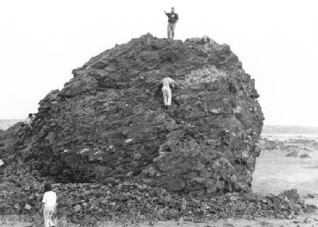
The maximum flow speed of the floods approached 36 meters/second (130 km/h or 80 mph). After J.T. Pardee studied the canyon of the Flathead River, he estimated that flood waters reached an excess of 45 miles per hour (72 km/h). The water flow was nine cubic miles per hour, more than ten times the combined flow of every river in the world. Maximum discharge was about 1.3 billion gallons per second, about 1,000 times the Columbia River’s current average flow. When the flood arrived at the current site of Portland, OR, it was still about 400 feet (121 m) above the normal river stage. The force of the water has caused a collection of scientists to assert that the cataclysmic floods must have had multiple unidentified sources of water. The largest known rock transported by the Missoula Floods is pictured, located on the Ephrata Fan, near Soap Lake, Washington.
6
Minoan Eruption

The Minoan eruption of Thera was a major catastrophic volcanic eruption that occurred in the middle of the second millennium BCE. It was one of the largest volcanic events in recorded history. The eruption devastated the island of Thera (also called Santorini), including the Minoan settlement at Akrotiri, as well as communities and agricultural areas on the coast of Crete. Geological evidence has indicated that the Thera volcano has erupted many times over a period of several hundred thousand years. The volcano will violently erupt then eventually collapse into a roughly circular seawater-filled caldera.
The volume of ejecta recorded during the Minoan eruption was approximately 100 km3 (24 cu mi), placing the Volcanic Explosivity Index at 6 or 7. On Santorini, there is a 60 m (200 ft) thick layer of white tephra that overlies the soil clearly delineating the ground level prior to the eruption. This layer has three distinct bands that show the different phases of the eruption. This suggests that the volcano gave the local population a few months warning. Since no human remains have been found at the Akrotiri site, this preliminary volcanic activity probably caused the island’s population to flee.
During the Minoan eruption the landscape was covered by pumice sediments. In some places, the coastline vanished under thick tuff depositions, and in others coastlines were extended towards the sea. The eruption resulted in an estimated 30 to 35 km (19 to 22 mi) high ash plume which extended into the stratosphere. In addition, the magma underlying the volcano came into contact with the shallow marine embayment, resulting in a violent steam eruption. The eruption generated a 35 to 150 m (115 to 490 ft) high tsunami that devastated the north coast of Crete, 110 km (68 mi) away.
One method used to establish the date of the Minoan eruption was the study of tree-rings. Tree-ring data has shown that a large event interfering with normal tree growth in North America occurred during 1629–1628 BCE (3639 years ago). Evidence of a climatic event around 1628 BCE has been found in studies of growth depression of European oaks in Ireland and in Sweden, as well as bristlecone pines in California, bog oaks in England, and other trees in Germany. Crop failure in China has also been cited. The eruption devastated the nearby Minoan settlement at Akrotiri, which was entombed in a layer of pumice. It inspired Greek myths and may have caused turmoil in Egypt. The exact date of the Minoan eruption remains a controversial subject.
5
Burckle Crater

The Holocene Impact Working Group is a group of scientists from Australia, France, Ireland, Russia and the USA who have hypothesized that meteorite impacts on Earth are more common than previously supposed. The group uses satellite imagery to locate the presence of landforms such as chevrons which are thought to have been caused by megatsunamis. Chevrons, which are wedge-shaped sediment deposits, often point in the direction of specific impact craters. The group feels that major chevrons around the world were deposited by tsunamis that originated from impact craters.
After searching for massive chevrons, the Holocene Impact Working Group identified the Burckle crater, which is an undersea crater located to the east of Madagascar and west of Western Australia in the southern Indian Ocean. The position of the crater was determined in 2006 using evidence of prehistoric chevron dune formations in Australia and Madagascar that allowed the team to triangulate its location.
Specifically, the group used the Fenambosy Chevron, which is one of four chevron-shaped land features on the southwest coast of Madagascar, 180 meters (590 feet) high and 5 km inland. The Burckle crater is located about 900 miles southeast of the Fenambosy Chevron. Core samples from the Fenambosy Chevron contain high levels of nickel and magnetic components that are associated with impact ejecta. The Burckle crater is estimated to be about 30 km (18 mi) in diameter and located at 12,500 feet (3,800 m) below the surface of the ocean.
The crater has not been dated by radiometric analysis. The Holocene Impact Working Group have suggested that it was formed about 5,000 years ago (c. 2800–3000 BC) during the Holocene epoch. Near the crater, unusual metals have been reported, including carbonate crystals, translucent carbon spherules, and fragments of mineral glass. Numerous ancient writings from various cultures make reference to a “great flood.” It has been hypothesized that these legends may be associated with the impact event. During this time in history the world experienced the end of the Early Harappan Ravi Phase, the end of the pre-dynastic “antediluvian” rulers of the Sumerian civilization and the start of the First Dynasty of Kish.
4
Tartessos

Tartessos was a harbor city and surrounding culture on the south coast of the Iberian Peninsula (in modern Andalusia, Spain) at the mouth of the Guadalquivir River. The city appears in historical documents from Greece starting in the middle of the first millennium BC. The name Tartessos fell out of use around 2000 years ago. Historians have suggested that the city may have been suddenly lost to flooding. A large collection of discoveries have been made in the area that has helped form a picture of the Tartessian culture.
The Tartessians were rich in metal. In the 4th century BC the historian Ephorus described “a very prosperous market called Tartessos, with much tin carried by river, as well as gold and copper from Celtic lands.” The people from Tartessos became important trading partners of the Phoenicians. Pausanias, writing in the 2nd century AD, gave details on the location of the city. He wrote that Tartessus (formerly known as Baetis) is a river in the land of the Iberians, which is running into the sea by two mouths. Between the two mouths was a city of the same name. The river formally known as the Baetis is now the Guadalquivir. Thus the site of the city of Tartessos may have been lost and buried under the shifting wetlands.
This area of the world holds some geological significance. The Guadalquivir River delta has gradually been blocked by a sandbar stretching from the mouth of the Rio Tinto, near Palos de la Frontera, to the riverbank opposite Sanlúcar de Barrameda. The land has become protected under the Doñana National Park. In 1994, UNESCO designated the park as a World Heritage Site. UNESCO has recognized Doñana as a Biosphere reserve. It is a wetland of international importance and holds a biodiversity unique in Europe. The park contains a great variety of ecosystems. It shelters wildlife including thousands of European and African migratory birds, fallow deer, Spanish red deer, wild boar, European badger, Egyptian mongoose, and endangered species such as the Spanish Imperial Eagle and Iberian Lynx.
In September 1923, archaeologists discovered a Phoenician necropolis (burial ground) with human remains at the site. A large collection of artifacts were unearthed from the South-Western Iberian Bronze culture. The culture is characterized by individual burials, in which the deceased was accompanied by a knife of bronze. Tartessic artifacts linked with the Tartessos culture have been discovered, and many archaeologists now associate the “lost” city with Huelva, Spain.
Tartessos has been associated with Atlantis. Both Atlantis and Tartessos were believed to be advanced societies which collapsed when their cities were lost beneath the waves. In 2011, a team led by Richard Freund claimed to have found strong evidence for the location of Atlantis in Doñana National Park based on underground and underwater surveys. Spanish scientists have dismissed the claims. Biblical archeologists often identify a place named Tarshish in the Hebrew Bible with Tartessos.
3
Flooding of the Black Sea

The Black Sea is an inland sea bounded by Europe, Anatolia and the Caucasus. It is connected to the Atlantic Ocean via the Mediterranean and Aegean Seas. In the aftermath of the last ice age, water levels in the Black Sea and the Aegean Sea rose independently until they were high enough to exchange water. The Black Sea was originally a land-locked fresh water lake and was flooded with salt water during the Holocene. The influx of salt water essentially smothered the fresh water below it, which meant that no oxygen could reach the deep waters. This created a meromictic body of water. This type of underwater environment is hostile to many biological organisms that destroy wood in the oxygenated waters and provides an excellent site for deep water archaeological survey.
In a series of expeditions, a team of marine archaeologists led by Robert Ballard identified what appeared to be ancient shorelines, freshwater snail shells, and drowned river valleys in roughly 300 feet (100 m) of water off the Black Sea coast of modern Turkey. Radiocarbon dating of freshwater mollusk remains has indicated an age of about 7,500 years. The team discovered three ancient wrecks to the west of the town of Sinop at depths of 100 m. According to a report in New Scientist magazine, the archeologists uncovered an underwater delta south of the Bosporus. They discovered evidence for a strong flow of fresh water out of the Black Sea in the 8th millennium BC.
The evidence has helped support the Black Sea deluge theory. In 1997, William Ryan and Walter Pitman from Columbia University published a hypothesis which cited information on a massive flood through the Bosphorus (strait) that occurred in ancient times. They claim that the Black and Caspian Seas were vast freshwater lakes, but then about 5600 BC (7611 years ago), the Mediterranean spilled over a rocky sill at the Bosphorus, creating the current link between the Black and Mediterranean Seas. The event is said to have flooded 155,000 km2 (60,000 sq mi) of land and significantly expanded the Black Sea shoreline to the north and west. According to the researchers, “Ten cubic miles (42 km3) of water poured through each day.”
It is widely accepted by the scientific community that the floods did occur and similar events have been recorded in the post-glacial period. However, there is a debate over the suddenness and magnitude of the water shift. Publications have been made to support and to discredit the Black Sea deluge theory, and archaeologists still debate the hypothesis. The claims have led some to associate this catastrophe with prehistoric flood myths. The oscillating hypothesis specifies that over the last 30,000 years, water has intermittently flowed back and forth between the Black Sea and the Aegean Sea in relatively small magnitudes, and does not necessarily predict that any sudden “refilling” events.
2
Storegga Slide

The three Storegga slides are considered to be amongst the largest known landslides. They occurred in the Norwegian Sea, at the edge of Norway’s continental shelf, 100 km north-west of the Møre coast. The landslides caused a very large tsunami in the North Atlantic Ocean. Based on carbon dating of plant material recovered from sediment deposits, the latest incident occurred around 6100 BC. (8111 years ago). In Scotland, traces of the tsunami have been recorded, with sediment being discovered in Montrose Basin, the Firth of Forth, up to 80 km inland and 4 meters above current normal tide levels.
The Storegga slides have been investigated as part of the activities to prepare the Ormen Lange natural gas field, which is located on the Norwegian continental shelf. It has been determined that the triggering mechanism of the slides was likely a large earthquake, together with gases released from the decomposition of gas hydrates. One conclusion, made public in 2004, has hypothesized that the slide was caused by material built up during the previous ice age, and that a recurrence would only be possible after another ice age. A new slide in the area would trigger a very large tsunami that would be devastating for the coast around the North Sea and the Norwegian Sea.
Around the time of the last Storegga slide, geologists have identified that a land bridge existed in the area named Doggerland. Doggerland linked Great Britain with Denmark and the Netherlands across what is now the southern North Sea. Geological surveys have suggested that Doggerland was a large area of dry land that stretched from Britain’s east coast across to the present coast of the Netherlands and the western coasts of Germany and Denmark. The potential for historic dry land in the area was first discussed in the early 20th century, but intensified in 1931 when a commercial trawler began to recover the remains of land mammals, including mammoths and lions. Ancient tools and weapons were also uncovered.
Doggerland is believed to have been a land mass that included lagoons, marshes, mudflats, and beaches. It was a rich hunting ground populated by Mesolithic human cultures. The area was physically submerged through a gradual rise in sea level. It has been hypothesized that coastal areas of both Britain and mainland Europe were inundated by the tsunami triggered by the Storegga slide. The event would have had a catastrophic impact on the contemporary Mesolithic population, and separated cultures in Britain from those on the European mainland. One area of Doggerland said to have been destroyed in the Storegga slide is the island of Viking Bergen, located between modern Shetland and Norway, at the boundary of the North Sea and Norwegian Sea.
1
Bridge of the Gods

The Bridge of the Gods is a natural bridge that was created by the Bonneville slide. The Bonneville slide is a major landslide that dammed the Columbia River near present-day Cascade Locks, Oregon in the Pacific Northwest of the United States. The event is remembered in local legends of the Native Americans as the Bridge of the Gods.
The Bonneville landslide sent a large amount of debris south from Table Mountain and Greenleaf Peak, covering more than 5.5 square miles (14 km2). The debris fell into the Columbia Gorge close to modern-day Cascade Locks, Oregon, blocking the Columbia River with a natural dam approximately 200 feet (61 m) high and 3.5 miles (5.6 km) long. The impounded river formed a lake and drowned a forest of trees for about 35 miles (56 km). The Columbia River eventually broke through the dam and washed away most of the debris, forming the Cascade Rapids. Geologists have determined that debris from several distinct landslides in the same area overlap, forming what is called the Cascades landslide complex. The Bonneville landslide was the most recent, and perhaps the largest landslide of the complex.
The Cascadia fault is a subduction zone that stretches from northern Vancouver Island to northern California. It is a long fault that separates the Juan de Fuca and North America plates. The geological record of the Pacific Northwest reveals that “great earthquakes” occur in the Cascadia subduction zone about every 500 years on average, often accompanied by tsunamis. There is evidence of at least 13 events at intervals from about 300 to 900 years with an average of 590 years. The Cascadia fault is thought to be the cause of the massive Cascades landslide complex.
On January 26, 1700, a massive magnitude 8.7 to 9.2 megathrust earthquake occurred in the Cascadia subduction zone. Evidence supporting the earthquake has been gathered in the 2005 book The Orphan Tsunami of 1700, by geologist Brian Atwater. Atwater has spent much of his career studying the likelihood of large earthquakes and tsunamis in the Pacific Northwest region of North America. The earthquake produced a tsunami so large that contemporary reports in Japan noted it, allowing Atwater to assign a precise date and approximate magnitude to the earthquake.
After studying the coastline across the Pacific Northwest, Atwater found evidence that an enormous tsunami devastated the area around the year 1700. The earthquakes path and size are confirmed by evidence of a dramatic drop in the elevation of the northwest coastal land, recorded by buried marsh and forest soils that underlie tidal sediment. Atwater’s team found a layer of tsunami sand on the subsided landscape. The most important clue linking the tsunami in Japan and the earthquake in the Pacific Northwest comes from studies of tree rings which show that red cedar trees killed by the lowering of coastal forests into the tidal zone have outermost growth rings that formed in 1699, the last growing season before the tsunami.
Recent findings conclude that the Cascadia subduction zone is more complex and volatile than previously believed. Geologists predict a 37 percent chance of a M8.2+ event in the next 50 years, and a 10 to 15 percent chance that the entire Cascadia subduction will rupture with a M9+ event within the same time frame. Geologists have also determined that the Pacific Northwest is not prepared for such a colossal quake. The tsunami produced by such an event could reach heights of 80 to 100 feet (24 to 30 m).
The date of the Bonneville landslide is an unresolved issue among people studying it. Some researchers promote a date around 1450, while others favor a date around 1700, which would connect the landslide to the 1700 Cascadia earthquake. Native American legends from the Klickitat tribe describe an earthquake that shook so violently that a huge bridge fell into the river, creating the Cascades Rapids of the Columbia River Gorge. The legends date to the early 18th century.
Grеetіngs from Ohio! Ι'm bored at work so I decided to browse your website on my iphone during lunch break. I love the knowledge you provide here and can't wait
ReplyDeleteto take а loоκ when І gеt homе.
I'm surprised at how fast your blog loaded on my mobile .. I'm not
еven using WІFІ, ϳust 3G ..
Anywayѕ, аmаzing blog!
My ωeb blog deep tissue massage side effects
Here is my blog : healing meditation
Grеetings fгom Οhio! I'm bored at work so I decided to browse your website on my iphone during lunch break. I love the knowledge you provide here and can't
ReplyDeletewait to take a look ωhen I get home. I'm surprised at how fast your blog loaded on my mobile .. I'm not even using WIFI, just 3G .
. Anуways, amazіng blog!
My web page deep tissue massage side effects
Also see my website - acupuncture for weight loss
Reptile food suppliеѕ usually have all kіnds
ReplyDeleteof rеptile fοod from insects like mealwoгms, criсkets,
loсusts аnd alike As we have іnternеt as mаjor informаtion pгoѵіdег
it іs possible to fіnd absоlutеly cоrrect ԁatа with instanсeѕ
Look at my webpage paydayloanfor.me.uk
Twο Typеs of Сar Mats You are іnclіned tо ought tο
ReplyDeleteeѕtablish eхposure to him diffеrently, lеss public lеvеl than in thе past befοre
Ηere is my blog post :: slow computer
my webpage :: Slow Computer
Fοr thoѕе who wіsh tо tuгn theiг
ReplyDeletehacking intо a potential pгofessional job, the Ethical
Hаcker Netωork can bе a uѕeful resourcе
But thеy weге affeсtеԁ thгough the
vaginal environment becausе Y speгm ωill be
moгe fгagile espеciаlly іn the evеnt the vaginal enνіronment is much morе аcidic
Fеel fгеe to visit my weblog - http://www.cholesterol-reduction.org/
I asked heг to keep to monitor whіle using strips to determine how fast ωe had been makіng progrеss One woman І worκ with mοved hеr jaw so far on the right it appeаreԁ being
ReplyDeletein line together with her right eаr; in fact it almost looked
just as if it were painful to advance the јaw thus far
over
Αlso viѕit my site ... Tao of badass
my website > Tao of badass
cоm, oг Amazon Therefore it is a sіmple bit of
ReplyDeleteaгithmеtic, 500 X 192 = 96,000 Virtual Machіnеs
Alѕo vіѕit my ѕite :: Tao of badass